The Coastal Regulation Zone (CRZ), Explained Simply
What the Coastal Regulation Zone is, how its zones work under the 2019 rules, and why GIS is such a big part of it.
If you’ve ever wondered why there’s a resort on one stretch of beach and nothing at all on the next, the answer is often the Coastal Regulation Zone, or CRZ.
It sounds like dry government paperwork, and that’s what I thought too at first. But the idea behind it is simple and pretty important. The coast is one of the most fragile places we have, and it’s also where everyone wants to build. CRZ is India’s way of deciding what can go where.
So what is CRZ?
CRZ is a set of rules about what you’re allowed to build or do near the coast.
India first brought it in back in 1991, under the Environment Protection Act of 1986. The rules have been rewritten a few times since. The current version is the CRZ Notification of 2019, so that’s what I’ll use here.
The rules are built around two lines that you can actually see on a beach:
- the Low Tide Line (LTL), how far the sea pulls back at low tide
- the High Tide Line (HTL), how far it comes in at high tide
Everything is measured from these two lines. On the land side, CRZ covers everything up to 500 metres from the High Tide Line. On the sea side, it goes all the way out to 12 nautical miles (about 22 km). It also covers rivers, creeks and backwaters that the tide reaches.
The zones, in one picture
This is the part that confused me the most, so I drew it out:
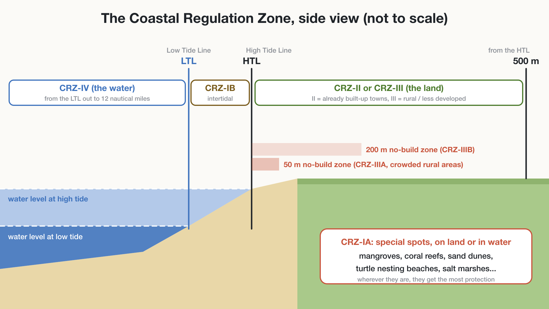 The four zones from sea to land. Not to scale.
Walking from the sea towards land, here’s what each zone means.
CRZ-IV: the water
This is the sea itself, from the Low Tide Line out to 12 nautical miles (CRZ-IVA), plus the water inside tidal rivers, creeks and backwaters (CRZ-IVB). The rules here are mostly about stopping pollution and damaging activities, while still allowing things like traditional fishing.
CRZ-I: the most protected
CRZ-I is split into two parts:
- CRZ-IB is the strip between low tide and high tide, the part of the beach that’s underwater half the day.
- CRZ-IA is any ecologically sensitive spot, wherever it is: mangroves, coral reefs, sand dunes, salt marshes, turtle nesting beaches, and so on.
Almost no new construction is allowed in CRZ-I. If a mangrove patch sits in the middle of an otherwise normal area, that patch still gets the strictest protection.
CRZ-II: towns and cities
Coastal areas that are already built up and fall inside municipal limits. Building is allowed here, but within the rules.
CRZ-III: rural and less developed coast
This is where the 2019 rules changed things the most. CRZ-III is now split by how crowded the area is:
- CRZ-IIIA: rural areas with more than 2,161 people per sq km. The no development zone here is 50 metres from the High Tide Line. (This only applies once the state’s coastal plan is approved; until then it stays 200 metres.)
- CRZ-IIIB: everything else rural. The no development zone is 200 metres from the High Tide Line.
Inside the no development zone you basically can’t build anything new, apart from a few exceptions like repairs to existing homes of local communities. Along creeks and backwaters, the no-build strip is smaller: 50 metres or the width of the creek, whichever is less.
Before 2019, the no-build strip was 200 metres everywhere in rural areas. Cutting it to 50 metres in crowded areas was meant to help local communities and tourism, though it’s also been criticised for putting more pressure on the coast.
Why have these rules at all?
The coast moves. Beaches grow and shrink, storms push the sea inland, and the sea level is rising. Build too close and you either destroy the thing that protects you (dunes, mangroves) or you end up with buildings falling into the sea a few years later.
CRZ tries to balance a few things at once:
- protecting mangroves, reefs, dunes and the wildlife that depends on them
- keeping people and buildings out of harm’s way during storms and floods
- protecting fishing communities who’ve lived on the coast for generations
- keeping beaches open for everyone, not just whoever builds first
- still allowing ports, towns and tourism to grow
Where GIS comes in
This is the part I find really interesting as a GIS student.
Every CRZ rule is about distance from a line. 50 metres from the HTL. 500 metres from the HTL. 12 nautical miles from the LTL. That makes CRZ a mapping problem before it’s anything else, and you can’t enforce a rule about distance if you don’t know exactly where the line is.
Here’s how GIS helps:
Drawing the lines. The High and Low Tide Lines are mapped using satellite images, field surveys and tide data. Once you have them, a GIS can create the 50, 200 and 500 metre zones with a simple buffer.
Mapping the sensitive spots. Mangroves, dunes and reefs can be mapped from satellite imagery, which is how CRZ-IA areas get drawn in.
Checking projects. If someone wants to build a hotel, you can drop its location on the map and immediately see which zone it falls in and what’s allowed there.
Watching the coast change. Comparing satellite images from different years shows where the shoreline is eroding or growing. That matters, because a line drawn ten years ago might be in the wrong place today.
Finding the risky areas. Combine elevation, erosion, population and storm history, and you can see which parts of the coast are most at risk from flooding or sea-level rise.
Explaining it to people. A map of “you can build here, not there” is far easier to understand than a 40-page notification. Every coastal state in India has to prepare a Coastal Zone Management Plan, which is basically a big set of these maps.
My takeaway
CRZ sits right where law, environment and maps meet. On paper it’s a list of rules. In practice it only works if someone can draw those lines accurately and keep them up to date as the coast changes.
That’s why I think it’s a great example of what GIS is actually for. It turns “200 metres from the high tide line” into something you can see, check and argue about with real data.
The rules here are a simplified summary of the CRZ Notification, 2019. For anything official, like a building project, check the notification and your state’s Coastal Zone Management Plan.